


The Landscape around the Lower Rhine in the Dark Ages changed dramatically becoming dominated by vast forests and woodlands. What was the explanation?
In the period known as the Dark Ages (c. 300 – 700 AD), woodlands staged a remarkable comeback across Europe, including the Netherlands. As human activity waned, forests and shrubberies reclaimed their lost territory, transforming the landscapes into a wilder world. The question is, however, what were the causes and the effects?
New Bioarchaeological Research

“The results indicate that landscape and human impact were the most important factors determining the vegetation structure and its changes. The pollen data show that in the present-day Netherlands, the clearance of woodland in the Roman period, followed by its regrowth afterwards, was greatest in the central river area, the delta between the Rhine and the Meuse. This can be linked to a high population density there during the Roman period followed by a strong decrease in population in the Dark Ages, but also to increased flooding”, writes Marjolein Gouw-Bouman.
The Landscapes and People in the Netherlands in the Dark Ages


Driving through the Netherlands gives precocious hints of what the landscape might have looked like in AD 300 – 700. At the coast, a landscape of sandy barriers, salt marshes, shoals, tidal creeks and tidal inlets bordered the boggy and peaty inland, receding further into the sandy higher ground. In the middle of the region, the vast deltas of the rivers Rhine and Meuse were initially dominated by natural vegetation consisting of mixed woods of oaks, ashes, hazels and alder trees. However, these woodlands had already been depleted at the time of Augustus.
Albeit a high level of discontinued habitations followed Caesar’s and Augustus’ conquests and the genocides described in De Bello, repopulation soon took place. To provide the army with recruits and supplies, large groups of people were actively “imported” from the East and North to be settled in the critical region, providing troops for Britain’s conquest.
Written sources mention that these people belonged to several German tribes, the Batavi, Suebi, Frisiones and others. Nonetheless, archaeology has shown how these deported and mottled migrants did not at first parade a unified material cultural (“tribal”) profile. Later, however, they were transformed into “tribes” through ethnogenesis. As it happened, these people ended up representing the core of what we came to know as the Frankish people in the 5th century.
At first, though, these migrants settled in this wet landscape building their houses on higher ground on the alluvial ridges or even on warfts, while exploiting the vast grazing in the river marshes. Also, they marketed and sold salt extracted from the tidal inlets. To get the salt, people heated the brine in saltpans by burning off peat, scrubs and whatever woody vegetation the earlier inhabitants had left.
With the Roman conquest of the area and the influx of Roman troops and garrisons to the new cities of Nijmegen, Voorburg, and others, the production of salt, salted beef, and leather for shoes and gear became a vast and important industrial enterprise, geared to feed the growing population as well as the Roman Army. When the population density peaked around AD 200, it measured 25/km2 in the river deltas, with the vast majority probably living in the large cities and towns.
Dark Age Catastrophe


Around AD 400, though, the party had long been over over. At this time, the population density had fallen to a measly 4/km2. This situation continued to worsen with some areas – the Southern sand areas being literally abandoned around AD 500-550. The literature tells us that an absolute low was registered around AD 475-500.
Arguably, the woodlands’ recovery and restitution resulted from this depopulation, writes Marjolein Gouw‑Bouman. Although the shifts in landscape differed from place to place, an overall pattern has been detected.
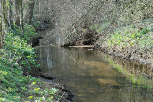
On average, the cover of trees grew by 24% in the river areas, with the area around Xanten showing an average growth of 40- 50%. The result was a darkened landscape interspersed with vast heaths to the North and abandoned grasslands to the south, which increasingly were covered in diffuse woodlands dominated by alder carrs such as those preserved at Xanten at the Bislicher Insel Nature Park.
Although the average temperature dropped ca. 1.5 Cº and flooding frequency grew, neither of these explanations is at the centre of Marjolein Gouw-Bouman’s argument. She notes how the depopulation and reforestation took off before the significant climatic catastrophe after AD 536-41 and – not least – before the Justinianic Plague set in sometime after AD 542.
This is also the explanation offered by Gerlach et al (2022), who has explored how the Rhine after ca. 300 got clogged up with silt after the continuous and laboursome stabilising of the riverbanks stopped, after which the Rhine got to act more like its natural self again. It started cutting new paths and mendreing anew, which reactivated the old landscape. While beech was prevalent around AD 400, hazel and alder came to dominate the riverscape after AD 500 indicating a wetter and more overgrown landscape.
The problem with dating and causation
However, the population estimates, on which this research has been based, were calculated by comparing the number of archaeologically investigated and surveyed sites, which are notoriously difficult to date precisely. Also, the question is whether lumping the dated sites into specific “periods” was somwhat skewered? What pattern of correlations might we get if the intervals of the time periods were shifted? To counter this argument, Groenwoudt and van Lanen explored the question concerning the actual decline in population through proxies such as cut wood, charcoal from kilns, and fibulae:
- Cut Wood. From AD 450 to AD 525, archaeologists could not register any imported and dendrochronologically dated individual wooden elements. However, the publication of this series suffers from having been lumped inside the aforementioned periodic intervals and not shown as a gliding curve. Also, this argument only concerns the development inside the settlements in the delta of the Rhine and Meuse, where the Roman military colonisation and later abandonment was most marked. Logically, there would be no reason to import building material to a region, where towns and cities were emptied of their garrisons.
- Charcoal Kilns. So far, charcoal kilns have only been found in the more sandy parts of the Netherlands, with no finds from ca. 400-650 when production took off again. Presumably, iron extraction did not take place during these 250 years. Again, though, the question of the exact dating is elusive.
- Fibulae. The study of numbers of well-datable fibulae also demonstrates a marked downturn after AD 270. However, again, the time intervals make it impossible to know exactly when depopulation started. Interestingly, though, the numbers indicate a marked downturn in around 270 but continuing after 450, creating a population density of a quarter of what was the case in the Middle Roman Period (AD 70 – 270), shedding light on the actual magnitude of the depopulation, which took place.
Conclusion
The connection between reforestation and depopulation, a significant phenomenon that gained momentum after the departure of the Roman army in the late 4th century, has been convincingly argued by Marjolein Gouw‑Bouman. She concludes that the reforestation was not a result of changing climate or colder weather. Nature’s land reclamation had already begun long before the catastrophic climatic downturn that occurred after AD 536-42.
However, this does not explain the continued reforestation, which ended ca. 650-800, when colonising settlements set off again. Between AD 400 – 650, stagnating population numbers continued to be the order of the day.
It seems reasonable to ask whether this later state of affairs was ultimately caused not by the initial migration out of the area, but by the advent of a marked climatic downturn accompanied by the Justinian plague. This has been demonstrated elsewhere on the Middle Rhine.
FOOTNOTES:
(1) REVEALS is a modelled approach by which pollen-data can be recalculated to compensate for the fact that different types of vegetation will dominate the raw data simply because they ( for instance trees) may be present in a high abundance, although their presence in the landscape was rather more limited.
SOURCES:
Several of these articles were carried out as part of the Dark Ages Project at the University of Utrecht
Late Holocene vegetation dynamics: degree and regional patterns of the Dark Ages woodland regeneration (AD 300–700) in the Netherlands
Marjolein T. I. J. Gouw‑Bouman
In Vegetation History and Archaeobotany (2024). Published under the Creative Commons Attribution 4.0. The diagrams above are quoted with reference to this CCA.
The Lower Rhine (Germany) in Late Antiquity: a time of dissolving structures
By Renate Gerlach, Jutta Meurers-Balke, A. J. Kalis
In: Netherlands Journal of Geosciences (2022).
Roman Imperialism and the Transformation of Rural Society in a Frontier Province
By Nico Roymans, Ton Derkes, and Stijn Heeren.
In: Brittania Vol 51 (2020), pp 265-294
Diverging decline. Reconstructing and validating (post-)Roman population trends (AD 0-1000) in the Rhine-Meuse delta (the Netherlands)
By Bert J. Groenwoudt and Rowin J. Van Lanen
In: European Journal of Postclassical Archaeologies, 2018, pp. 189-218.
The Lower Rhine (Germany) in Late Antiquity: a tme of dissolving structures.
By Renate Gerlach, Jutta Meurers-Balke and Arie J. Kalls
In: NetherlandsJournal of Geosciences 2022. (Open Access)